Sailing on and on


Navigation was based on advances in the science of cartography and their dissemination in printed form. Navigation techniques evolved as a result of the invention of specific instruments for this purpose.

The primitive navigation chart was the "portolanic map", which showed the routes and was drawn up in the shape of a spider's web.
The cartographic revolution began in 1569 when Gerard Mercator published his first nautical charts and atlas with the "cylindrical" projection, which was a new way of showing the world map.
In ancient times, an experienced navigator calculated both speed and the distance covered by "guesswork"; those were the days of "fantasy sea voyages".
However, in the 15th century, the "navigating needle" was in general use. This was a compass which made it easier to follow sea routes. The distance covered was calculated using an "hourglass" containing sand.
The speed of the vessel was calculated by means of a piece of apparatus using rope marked out with equidistant knots or metal discs.
The problem of fixing geographical location was resolved with the use of the "astrolabe", which made it possible to measure the angle of the sun and that of the pole star. Advances in the development of these instruments made such calculations easier and more precise, for example: the "course protractor", the "cuadrant", the "octant and the sextant", and the "longitude clock", which was a precision chronometer.
The "art of navigating" became a technical science, and news of it was spread through navigation treatises. From 1519 onwards (the Suma Geográfica, by Fernández de Enciso) a significant number of contributions to this science were written by Spaniards.

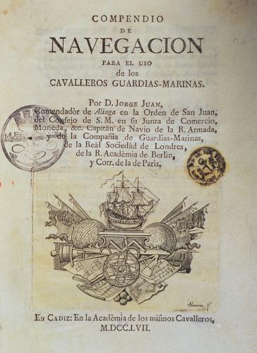
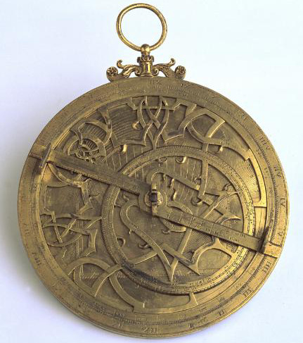
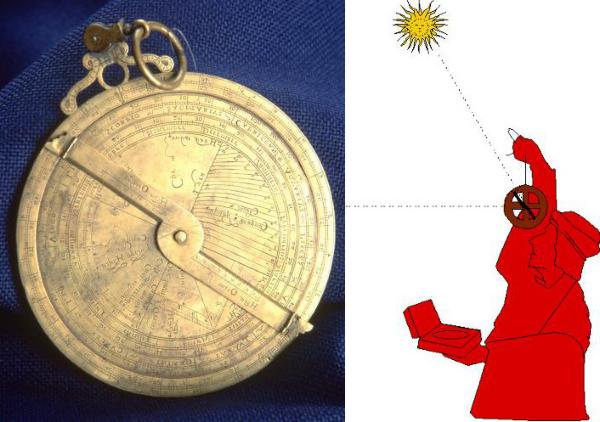
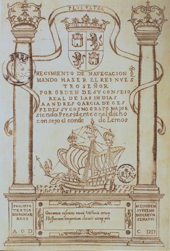
Regimiento de navegación. Andrés García de Céspedes. Madrid, 1605. MN. Throughout the 16th and 17th centuries, it was the Spaniards and the Portuguese who systematically compiled, developed and expounded upon the theory and practice of navigation. The work of Céspedes corrected the errors of earlier treatises and this became one of the most important nautical treatises of the period. Title page of the Compendio de navegación. Jorge Juan. Cádiz, 1757. MN. Jorge Juan, together with Ensenada, was the great pioneer of all initiatives undertaken in an effort to reorganize the Armada, and was one of the major exponents of science in Spain in the 18th century. Works such as this meant that the teaching of navigation techniques could undergo reform, and introduced into Spain the latest advances in science of the European Age of Enlightenment.


16th century astronomical astrolabe. MN. To begin with, the astrolabe was used for the recording of specific celestial phenomena for astronomical and astrological purposes. They were either spherical or flat, these latter being applied to navigation.


Spanish universal astrolabe. 1563. MN. This was invented in the 11th century by Azarquiel, a native of Toledo. These instruments were used to find the height of the sun or the stars in order to calculate latitude.


A two-sector quadrant. 18th century. MN. This was used to observe and determine the height of heavenly bodies in order to calculate the latitude of the ship when at sea.


Nautical quadrant. 16th century. MN. This was one more advance in the search for a solution to the problem of finding the actual geographical position of vessels. As it substituted the spaced-out lines of the astronomical spyglass with graduated arcs, it allowed for greater accuracy.


Astronomical spyglass. 18th century. MN. This instrument began to be used by pilots in the 16th century for measuring the altitude of the Pole star. It remained in use until the 18th century and comprised a series of plates showing different graduations.


18th century sextant. MN This is a goniometer or instrument for measuring angles; it was a precision instrument, lightweight and easy to transport, and was used at sea to measure distances by angle and the height of heavenly bodies, which permitted the observer to determine his position.


Marine chronometer dating from the end of the 18th century. MN With the invention of this instrument, which told the time with a sufficient degree of accuracy, the problem of finding the geographical longitude of the vessel was solved, as this was vital for fixing positions to the east or west of a specific meridian.


Equinoctial sundial. 1599. MN This instrument showed the time with more accuracy than the hourglass, the clepsydra or the water-clock. Hourglass used in the 18th and 19th centuries. MN Up until the early 11th century, the best known method for measuring small intervals of time was the hourglass. This was used to regulate life aboard the ship and to calculate its speed.


Title page of the Suma de Geographia. Martín Fernández Enciso. Seville, 1519. MN This work contains the first description of the lands comprising the New World, with particular reference to their coasts. It includes a treatise on navigation and some tables showing solar declinations. Regimiento de navegación. Pedro de Medina. Seville, 1563. MN Volume two of this navigation rulebook gave instructions for measuring the height of the sun with a nautical astrolabe.


Title page of the Regimiento de navegación. Pedro de Medina. Seville, 1563. MN Rulebooks were a type of treatise on navigation for practical use by pilots. They were written in the form of recommendations and rules, the "Casa de Contratación" being responsible for their custody and diffusion. The Gunter sector. 17th and 18th centuries. MN This compass was used in mathematical calculations for solving navigation problems in the area of flat triangles and spheres.


Nautical speed-measuring wheel. MN This instrument was used to determine the speed of the vessel. A rope with knots at regular intervals and wound round a wheel was released overboard at the stern of the ship as it moved forward, and the number of knots released over a certain period of time were then counted.