The "Virreinato" of New Spain


The Spanish Crown organized a set of institutions for the administration and government of its territories in the New World.

The "virreinatos" of New Spain and Peru headed the organization of territories in the New World that were under the control of the Spanish Crown up until the 18th century, when the "virreinatos" of New Granada and Río de la Plata were created.
The "virreinatos" were divided into regional demarcations known as governments. Each government was responsible for a territory with a specific number of towns or villages which were grouped together and controlled by magistracies.
From the point of view of administration of justice, the territory was divided into "audiencias" and, in accordance with military bureacracy, into captaincies, which were located in the principal regional governments. The Philippine "Audiencia" and Government came under the control of the "virreinato" of New Spain.
Right from the start, cities were the nerve centres of all divisions of the administration, and the headquarters of all civil, ecclesiastical and military bodies were located there.
Each city was governed and administered by an institution imported directly from Spain: the town council, known as the "cabildo". A flow of ideas, people and merchandise began to be exchanged between the territories of the "virreinato" of New Spain and the Philippine Islands, and over the centuries this created a permanent nexus between Asia and America.

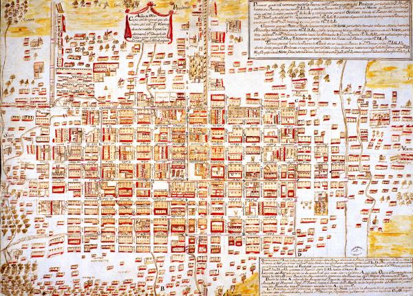
Plan of the city of Mexico, divided into districts. 1782. Manuel Villavicencio. AGI. During the 18th century, demarcations between neighbourhoods were determined for purely administrative purposes. The physical division made between one neighbourhood and another was generally performed on the basis of "districts".
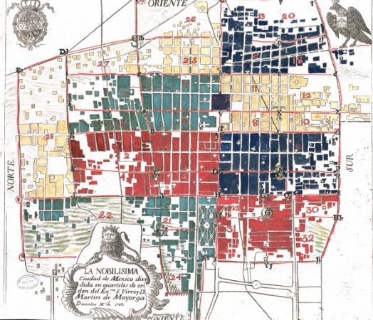

"Plaza de Armas" in Mexico, with the Cathedral in the background. C. Castro. 19th century. BN. If the "cuadrícula" or grid system was the formal way in which the Hispano-American city was structured, then the "plaza mayor", "plaza de armas" or "plaza", is the element that arranges and orders each and every urban settlement.


The city of Mexico in the mid-18th century. AGI. During the 18th century, the Bourbon spirit of ordering all things attempted to give many areas of the capital a more dignified air, with particular reference to its main "plaza"


Aerial view of the city of Mexico. C. Castro. 19th century. BN. In the 19th century several programmes for making cities more beautiful were initiated. Streets were widened, new "plazas" were opened and the old ones were turned into gardens, changing their appearance. In general terms, cities turned away from the old Spanish colonial structure and incorporated new European trends.


Pintura del gobernador, alcaldes y regidores. Códice de Osuna. 1565. BN. Mexico, capital of the viceroyalty of New Spain, was built upon the ruins of the Aztec city of Tenochtitlan, after it was destroyed by the troops of Hernán Cortés.


The Caribbean, in the World Islands Map. Alonso de Santa Cruz. 16th century. BN. The viceroyalty of New Spain, created in 1535, included under one generic title a whole range of different, vast territories, ranging from the kingdom of Guatemala to the rich mining regions of the north, which were organized around one hub: the city of Mexico. It also included practically the whole of the Caribbean area.